From Darkness to Knowledge: Unveiling the Temporal Evolution of the Škocjan Caves System
Project Team
Franci Gabrovšek, PhD, Blaž Kogovšek, PhD, Filip Šarc-
ARIS Project ID
L1-70058
-
Duration
1 March 2026–28 February 2029 -
Project Leader
-
Financial Source
Javna agencija za znanstvenoraziskovalno in inovacijsko dejavnost Republike Slovenije

Javni zavod Park Škocjanske jame, Slovenija

Slovenska akademija znanosti in umetnosti (SAZU)

The Škocjan Caves area in south-western Slovenia is internationally renowned for its exceptional karst features, including one of the world’s largest underground canyons, extensive collapse dolines, and remarkably well-preserved sedimentary archives. Inscribed on the UNESCO World Heritage List in 1986, the Škocjan Caves constitute a natural laboratory for investigating speleogenetic processes, hydrological dynamics, and the interactions between environmental and geological controls. Despite decades of research, key questions concerning the temporal and spatial evolution of the cave system remain unresolved, particularly with respect to the influence of climatic variability, tectonic activity, and flood events.
Existing studies are partly fragmented and do not yet provide an integrated understanding of cave and karst evolution as a coupled system. The project therefore implements a new programme of field mapping, sampling, laboratory analyses, and numerical modelling, and will synthesise the resulting evidence into a comprehensive spatio-temporal model of the evolution of the Škocjan Caves. Such a model also addresses a key need identified by the co-funder, the Škocjan Caves Park, as it directly supports informed management, conservation, and interpretation of the site.
The applied research project has five main objectives:
- to analyse the spatial distribution of cave passages and sediments in order to identify hydrological and speleogenetic patterns;
- to establish the chronology and environmental conditions associated with the main phases of cave development;
- to model the formation and evolution of the underground canyon and collapse dolines;
- to synthesise new and existing knowledge into a conceptual time-resolved model of karst system evolution; and
- to develop tools for public education and outreach, including a 3D animation illustrating the evolution of the Škocjan Caves and an educational monograph focused on their spatial and temporal development.
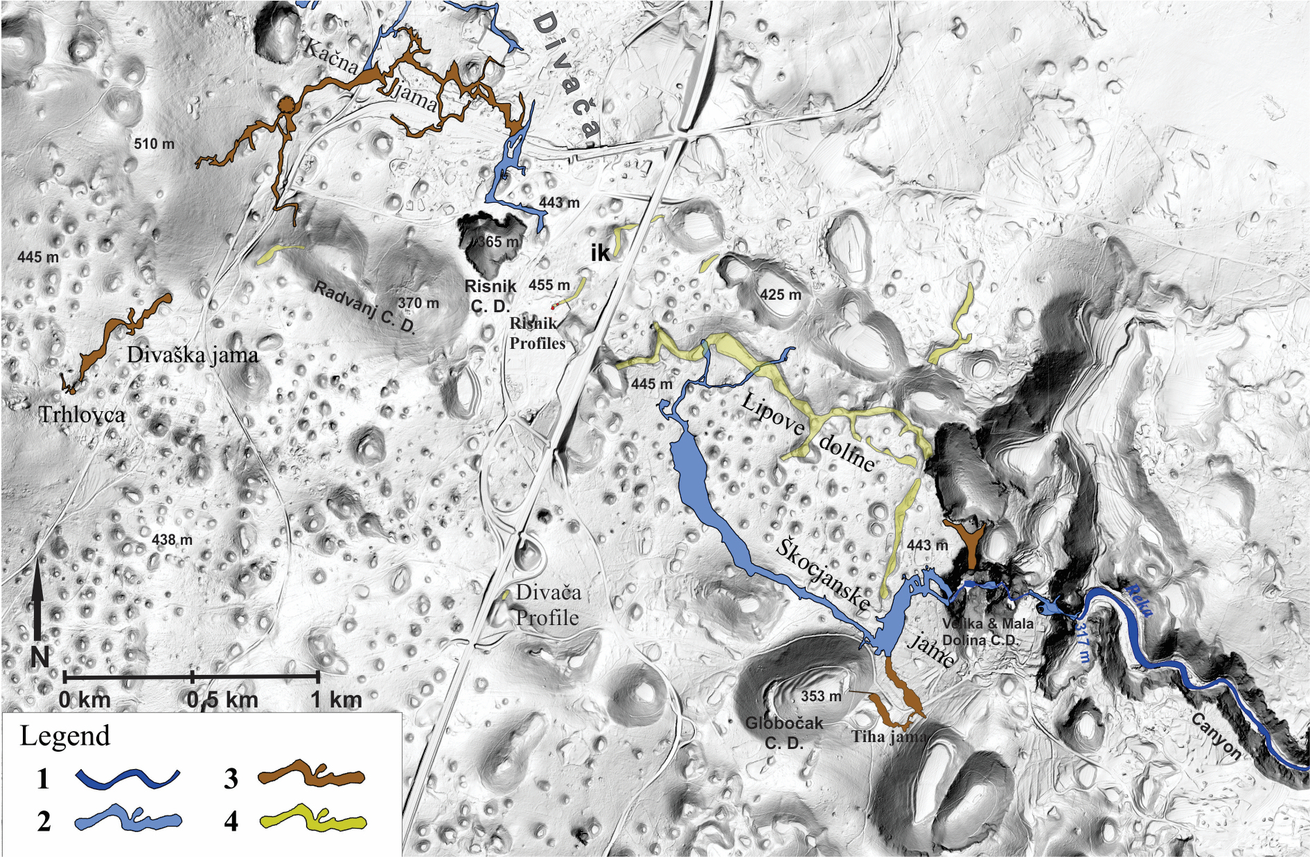
Locations of major relict and active caves with studied sediment sites (based on published and unpublished results; based on Zupan Hajna et al., 2024) shown on a hill-shaded DEM of the Divača Karst. Legend: 1. Surface river; 2. Underground river cave passages; 3. Dry cave passages; 4. Unroofed caves.
Work Packages:
Work Package 1: Geomorphological mapping and analysis of karst landforms
Field documentation of collapse dolines, unroofed/open caves, and surface features linked to subsurface processes. High-resolution methods will be applied, including LiDAR, electrical resistivity tomography (ERT), and 3D laser scanning, enabling detailed spatial analysis.
Work Package 2: Sediment analyses
This work package comprises multi-proxy investigations of cave sediments to determine their composition, provenance, and age. Advanced analytical techniques will be employed, including X-ray powder diffraction (XRD), X-ray fluorescence (XRF) spectrometry, palaeomagnetic analyses, and radiometric dating.
Work Package 3: Numerical modelling
This work package is based on simulations of key processes such as sediment transport, incision and deepening of the underground canyon, and the formation of collapse dolines. The models will incorporate key controlling factors, including chemical dissolution, mechanical erosion, and hydrological change.
Work Package 4: Synthesis of results
All datasets will be integrated into a comprehensive spatio-temporal model, which will be visualised through 3D visualisations/animations and presented in an educational monograph.
Research impact
The project will deliver significant scientific and practical impact. In addition to developing a spatio-temporal model, it will improve understanding of the principal phases of speleogenesis and the evolution of karst systems. The 3D visualisations/animations will communicate complex hydrological processes and the development of cave conduits, while the educational monograph will increase public awareness of the value of karst landscapes. The project will also contribute to the conservation and informed management of the Škocjan Caves as a UNESCO World Heritage Site and will provide a framework for further research on karst systems at the global scale.
Implementation plan
The implementation plan follows a clearly defined timeline structured into quarterly periods over three years. The first year will focus on fieldwork, geomorphological mapping, and sediment sampling. The second year will be dedicated to laboratory analyses and numerical simulations, while the third year will concentrate on synthesis of results, production of the 3D visualisations/ animations, and final project presentation. Dissemination activities will be embedded throughout all phases, enabling ongoing knowledge exchange with stakeholders and the wider public.